HIGHFIRE RISK PROJECT

VLS EVENTS

DateLocationLongitude (d.dd°)Latitude (d.dd°)Elevation (m)Code
26 Jan 2003 Thredbo #1 148.39 -36.45 1400 030126D
26 Jan 2003 Thredbo #2 148.43 -36.43 1500 030126E
26 Jan 2003 Thredbo #3 148.46 -36.41 1500 030126F
26 Jan 2003 Thredbo #4 148.55 -36.38 1200 030126G

This fire was part of the south-eastern expansion of the main Kosciuszko fires after they had been burning for 18 days. It is in NSW, and within Kosciuszko National Park, but close to private property.
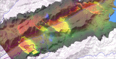
In an extraordinary set of events, four VLS events burnt in the Thredbo Valley at the same time. Each was linked to the upwind, or northwest, edge of the valley of a spurline in the valley, and burnt to the southwest, with expansion either to the northeast of southwest.
Click here for full-size
Map of the Thredbo Valley, with Lake Jindabyne of the right, and Thredbo Village in the lower left corner (spanning approx. 30km west to east). The river junction near the centre of the image is Bullock Flats. The linescans are overlaid on this to show the multiple, simultaneous, parallel fire channelling events.

This aerial view shows the plume of one of the events [030126F], near Bullock Flats. The VLS is anchored to the spurline, visible on the left-hand edge of the photo. The prevailling winds are pushing embers to the right, while the event is expanding towards the camera.
A close up showing the main road along the Thredbo River. Note the spotfires forming the fire extent on the uphill run out of the river.
An even closer view, showing fire trucks positioned at the edge of the event. Had the expansion been more vigorous in this direction the trucks would have been in major peril.
This aerial view shows the upwind edge of the event, on the lip of the alpine plateau near Perisher Village. Note how the valley is filled with the convection, but it is expanding upwards into the prevailling winds. Whispy foreground smoke is from non-channelled fire on the plateau.


This material is from video taken during an aerial reconnaissance mission flown by Australian Customs for the ACT Bushfire Service. The multispectral linescans were flown by Air Target Services Pty Ltd for the NSW Rural Fire Service. Terrain model and contours are derived from Shuttle Radar Terrain Mission data.