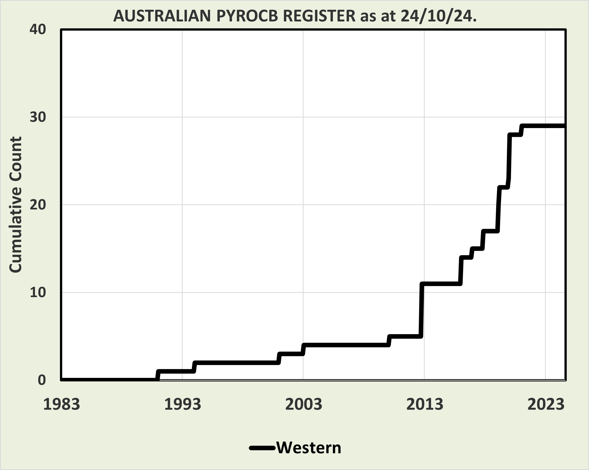
| ID | EVENT | YEAR | DATE (dd/mm/yyyy) | STATE | LOCATION | LONGITUDE | LATITUDE | LEVEL OF CONFIDENCE |
| 1991a | 1991 (08 Jan) WA: Peak Charles | 1991 | 08/01/1991 | WA | Peak Charles | 121.1 | -32.8 | High |
| 1994a | 1994 (23 Jan) WA: WSW Kalgoorlie | 1994 | 23/01/1994 | WA | WSW Kalgoorlie | 120 | -32 | Moderate |
| 2001a | 2001 (18 Jan) WA: Splinter Rock | 2001 | 18/01/2001 | WA | Splinter Rock | 122.9 | -33.1 | Very high |
| 2003a | 2003 (10 Jan) WA: Mount Cooke | 2003 | 10/01/2003 | WA | Mount Cooke | 116.3 | -32.4 | Very high |
| 2010a | 2010 (18 Feb) WA: Esperance | 2010 | 18/02/2010 | WA | Esperance | 122.2 | -33.1 | Very high |
| 2012a | 2012 (18 Oct) WA: Deserts | 2012 | 18/10/2012 | WA | Deserts | 125.1 | -27.3 | Very high |
| 2012b | 2012 (18 Oct) WA: Deserts | 2012 | 18/10/2012 | WA | Deserts | 124.8 | -26.5 | Very high |
| 2012c | 2012 (18 Oct) WA: Deserts | 2012 | 18/10/2012 | WA | Deserts | 126.7 | -27.4 | Very high |
| 2012d | 2012 (18 Oct) WA: Deserts | 2012 | 18/10/2012 | WA | Deserts | 126 | -27.6 | Very high |
| 2012e | 2012 (18 Oct) WA: Deserts | 2012 | 18/10/2012 | WA | Deserts | 126.7 | -28.3 | Very high |
| 2012f | 2012 (29 Oct) WA: Deserts | 2012 | 29/10/2012 | WA | Deserts | 122.8 | -28.5 | Very high |
| 2016a | 2016 (06 Jan) WA: Waroona | 2016 | 06/01/2016 | WA | Waroona | 116 | -32.9 | Very high |
| 2016b | 2016 (07 Jan) WA: Waroona | 2016 | 07/01/2016 | WA | Waroona | 116 | -32.9 | Very high |
| 2016c | 2016 (07 Jan) WA: Waroona | 2016 | 07/01/2016 | WA | Waroona | 116 | -32.9 | Very high |
| 2016f | 2016 (07 Dec) WA: Cocklebiddy | 2016 | 07/12/2016 | WA | Cocklebiddy | 126 | -32.1 | Very high |
| 2017b | 2017 (08 Nov) WA: Table Hill | 2017 | 08/11/2017 | WA | Table Hill | 117.02 | -34.65 | Very high |
| 2017c | 2017 (08 Nov) WA: Table Hill | 2017 | 08/11/2017 | WA | Table Hill | 117.16 | -34.69 | Very high |
| 2019d | 2019 (27 Feb) WA: Goldfields | 2019 | 27/02/2019 | WA | Goldfields | 120.7 | -32.5 | Very high |
| 2019e | 2019 (27 Feb) WA: Goldfields | 2019 | 27/02/2019 | WA | Goldfields | 122.7 | -33 | Very high |
| 2019f | 2019 (27 Feb) WA: Goldfields | 2019 | 27/02/2019 | WA | Goldfields | 122.7 | -33 | Very high |
| 2019g | 2019 (01 Mar) WA: Goldfields | 2019 | 01/03/2019 | WA | Goldfields | 124.5 | -24.5 | Very high |
| 2019h | 2019 (01 Mar) WA: Goldfields | 2019 | 01/03/2019 | WA | Goldfields | 124.3 | -28.5 | Very high |
| 2019y | 2019 (18 Dec) WA: Esperance | 2019 | 18/12/2019 | WA | Esperance | 120 | -32.6 | Very high |
| 2020f | 2020 (08 Jan) WA: Belladonia | 2020 | 08/01/2020 | WA | Belladonia | 123.2 | -32.7 | Very high |
| 2020g | 2020 (08 Jan) WA: Belladonia | 2020 | 08/01/2020 | WA | Belladonia | 123.9 | -33.1 | Very high |
| 2020h | 2020 (08 Jan) WA: Bald Rock Fire | 2020 | 08/01/2020 | WA | Bald Rock Fire | 119.6 | -32.5 | Moderate |
| 2020i | 2020 (08 Jan) WA: Lake King Fire | 2020 | 08/01/2020 | WA | Lake King Fire | 120 | -33 | Moderate |
| 2020j | 2020 (08 Jan) WA: Wingarnie | 2020 | 08/01/2020 | WA | Wingarnie | 121.6 | -31.9 | Moderate |
| 2021a | 2021 (23 Jan) WA: Balladonia | 2021 | 23/01/2021 | WA | Balladonia | 123.52 | -32.05 | Very high |
| 2025c | 2025 (24 Jan) WA: Forrestiana Gold Field | 2025 | 24/01/2025 | WA | Forrestiana Gold Field | 119.8 | -32 | Very high |
 .....
.....